
Stereo analysis
AnalyzedVerdict
Monoview (identical duplicate)67%
A monoview: the same photograph printed twice, so no genuine stereoscopic depth is present.
- Depth spread
- 1px
- The range of horizontal difference between the two views. More spread generally means more depth; 0–1 px usually indicates a monoview.
- Match
- 100%
- The share of usable picture detail that can be matched between the left and right views. A higher number means a more reliable comparison.
- Vertical
- 1px
- Vertical drift between matched details. Lower is better; 4 px or more can indicate camera movement, scan skew, or poor alignment.
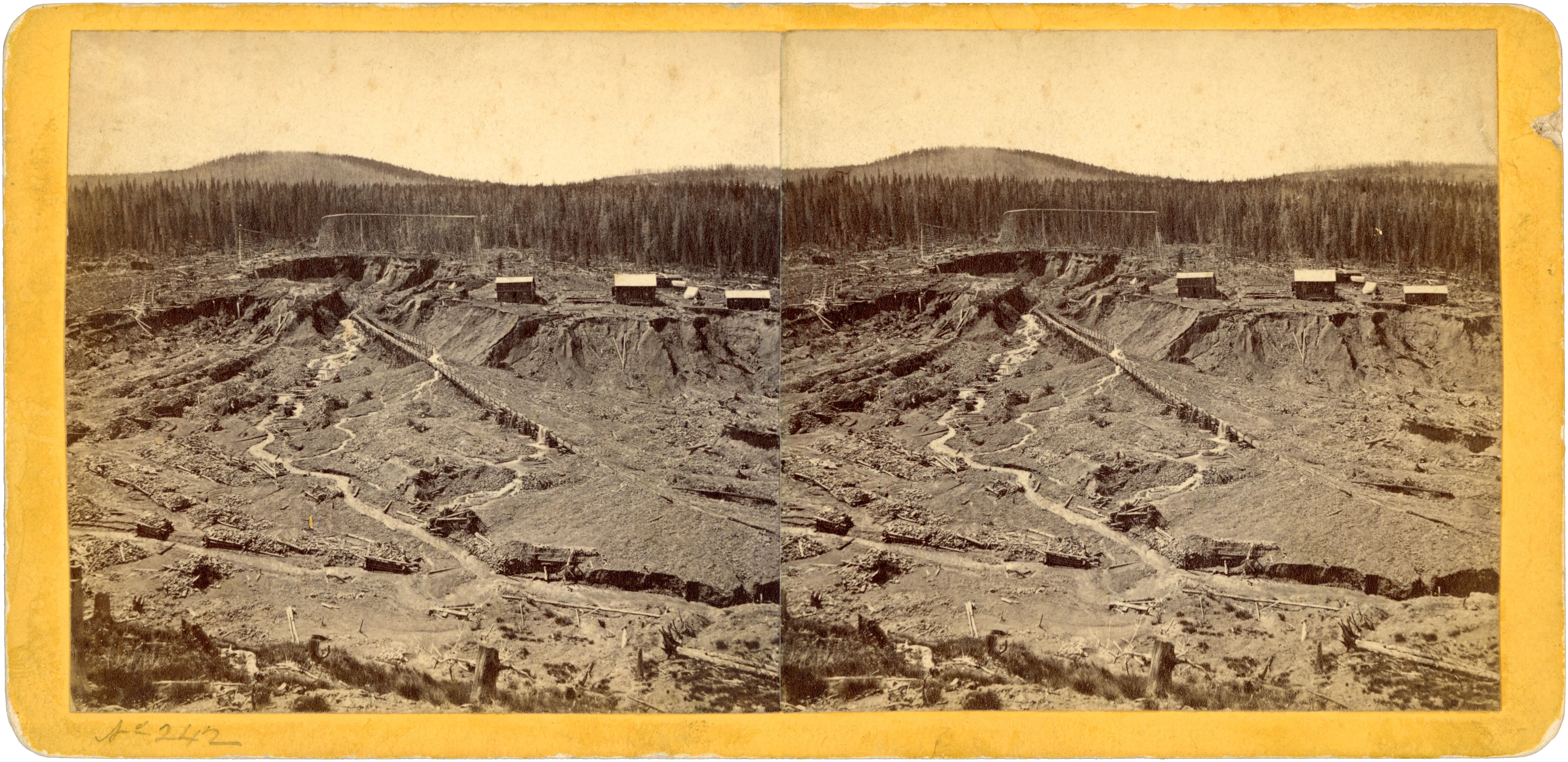
A stereoview on a yellow, round-cornered mount, showing an extensive mining excavation. The printed reverse identifies the subject as “Gold Run—Hydraulic Mining,” locates it in Summit County, Colorado, and carries the credit “Photographed by W. G. Chamberlain. Denver.”
A long timber flume crosses the workings diagonally on trestle supports. Below it, a winding channel passes between banks of excavated material, scattered timber, and cut stumps. Small roofed buildings occupy the far bank, while tall timber framing stands near the forest edge. The paired photographs retain considerable detail in the supports, channels, and exposed ground.
The reverse carries the heading “Colorado Mountain Scenery,” with “Rocky Mountain Scenery” printed along the margins. Its accompanying account emphasizes the district’s placer mines and describes the use of “Bed-rock Flumes and Hydraulics.” These printed statements supply the locality and mining identification. No date is printed, and the photographic process cannot be established from the scans.
A small loss at the mount’s right edge exposes the card beneath the yellow covering. A localized dark spot with surrounding staining is present on the reverse. The photographs are otherwise clean, and the card appears sound.
- Title on card
- GOLD RUN. Hydraulic Mining.
- Medium
- Stereoview
- Subject
- Colorado, Mining, Occupational, Outdoor Scene, Yellow Mount
- Dimensions
- 6.90 × 3.34 in (175.3 × 84.9 mm)
- Condition
- Small loss to the yellow covering at the mount’s right edge; localized dark spot with surrounding staining on the reverse. Photographs otherwise clean, and the card appears sound.
- Provenance
- Printed photographer’s credit on the reverse: “Photographed by W. G. Chamberlain. Denver.” No ownership history is established by the visible markings.
- Catalogue no.
- MSV1743
Catalogue details
Location
Gold Run Gulch hydraulic-mining district, near Breckenridge · Summit County, Colorado, United States
Photographed subject · Street / district · 60% confidence
The inscription establishes Gold Run, Summit County. Summit Historical Society identifies Gold Run Gulch as the placer-mining district, while Breckenridge History locates the Gold Run area near the Breckenridge Golf Course and describes its connection to Preston and Gibson Hill. ([summithistorical.org](https://summithistorical.org/colorado-150/august/)) USGS independently confirms hydraulic mining at Gold Run near Breckenridge. ([pubs.usgs.gov](https://pubs.usgs.gov/circ/1400/circ1400.pdf?utm_source=openai)) Coordinates are the published gazetteer point for Gold Run Gulch, used only as a district locator; they are not the documented position of the photographed flume, excavation, buildings, or camera. No exact feature footprint or viewpoint was established. ([mapcarta.com](https://mapcarta.com/23192238))